Holiday Sketches – An Autumn Day on Corradhina Mountain, Co. Tyrone
Looking NNW
Now that holiday making is the order of the day and people scarcely know where to go for a days outing, there are so many places of interest in our own province of Ulster, where whole weeks could be so pleasantly spent, and pure air had in plenty; so many of these places are so well known, it just occurred to me that Corradhina (Corradina) Mountain might be unknown to some.
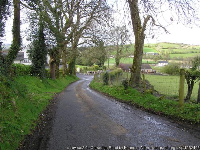
This mountain lies in N. W. Tyrone, about 3 miles from the flourishing town of Omagh, 3 from Drumquin, 5 from Dromore, and about the same from Fintona. It’s highest peak, locally known as “The Green Top”, has an elevation of about 1,000 feet, access can be had to it by three roads running due N. S. and W.
Up to a few years ago, it was only with the greatest difficulty and at considerable risk of wet feet and soiled clothes, except dry weather, that this top could be reached, particularly from the Drumquin side, but now the road is in good order for walking, driving, or even cycling on.
From whatever side the top is approached, the road is a succession of high hills and deep valleys, some of which are of the wildest and loneliest character, one, on its Northern side, known as “The Hollow Bridge” from the singularly wild and weird character of the place, surrounded on all sides by mountains without a single habitation, except a herd house. The bridge has no wall and the roar of the torrent, as it rages down the mountain side, after heavy rains, the copper colour of its waters, owing to its taking its rise near to, or passing over, an iron mine in its course, mingling with the black mud of the mountains, the deep gorge made by the torrent in the course of centuries, the absence of wild fowls, except the solitary crane or heron flying past to more tranquil waters, can be better imagined than described.
From this bridge, the road is a continual climb. Imagine yourself standing in a plateau of heather, four miles N. S. E. and West, heather gradually and by successive terraces sloping lower and lower till cultivation is reached, then a fertile plain, with highly cultivated farms, comfortable homesteads, stately churches, noble forests and such rivers the Strule, Mourne, Finn, and Owenrea can be seen at times, meandering among the trees and holms. A few lakes are also visible. Almost at the base of the mountain stands the little parish church of Upper Langfield – Magherenny, with its sheltered graveyard, where many of the brave and true “forefathers of this hamlet sleep”; a little to the right, Dressog National School, one of the most popular in the district; further on the Drumquin Presbyterian and Methodist Churches and at present known as “crooked bridge”, the Roman Catholic Chapel. To the other side is the prosperous and important town of Omagh, with its numerous public buildings and churches, while to the south and west may be seen in the distance the towns of Fintona and Dromore.
Beyond this plain rises another chain of mountains, among which are the far-famed Bessie Bell, Mary Gray, Glenhordial, the Gortin mountains, Fivemiletown mountains, Granan Peak, the Barr mountains, &c., and beyond these again another series of mountains. The summits of two seem to run up into the clouds, one called “Cock of the North”, by the people of the place and the other called “Blue Stack” are said to be visible far out in the Atlantic and are on many a tearful eye as the American steamer proudly sails round “The Head.”
The effect of those heather-covered mountains, whose peaks are so distinctly visible against the sky, is simply magnificent. A bright day is all that is wanted to make the view perfect and the visitor to Corradhina mountain will have something to think of besides their dinner, which, by the way, they should not forget. An atheist could not be an atheist for five minutes longer after spending the day on “Green Top.”
H. J. S.
NOTE: If you can help identify this Mountain today, please contact me.
Transcribed by Teena from the Tyrone Constitution Edition of 4 Sept. 1896