According to the Ordnance Survey, the Barony of Farney contains 67,436 acres, 8 perches.
In the year 1585 and the 27th year of Elizabeth’s reign, the area of Ulster, distinguished after the Anglo Norman Invasion as Irish Uriell or Oriell, and M’Mahons Country, and now referred to as the County of Monaghan, was first made into “Shire Ground” and subdivided into 5 Baronies.
Monaghan, Trough, Dartry, Cremourne and Donaghmoyne.
The Barony of Donaghmoyne is more generally known, both before that time, and since, from its ancient meaning of “the plain of the Alder-trees” and was called FERNEY, or FARNEY. The Barony of Farney, is in the most southern part of the County and borders on the Counties of Cavan, Meath, Louth and Armagh and it is divided into 5 Parishes –
- Parish of Donaghmoyne containing 25,603 acres, 3, roods, 30, perches.
2) Parish of Magheross 16,702 acres 0r., 30p, (Now Carrickmacross – 16,667.2 acres or 26 sq. miles)
There are b/m/d’s 1660-67 Magheross (& more) in Appendix V in the book The History of the County of Monaghan by E.P. Shirley http://goo.gl/T2BteH
3) Parish of Magheracloone means ‘plain of meadow’ 14,951 acres 3r., 32r. (today 12,952 statute acres) – and is derived from its most important place in ancient times; a flat area of land in the townland of Camaghy, on which the ancient church of St. Molua was located. Mined locally is gypsum, one of the many natural resources.
Magheracloony
a parish in the barony of Farney, county of Monaghan and province of Ulster, 2½ miles S.W. from Kingscourt on the confines of the counties of Louth, Cavan, and Meath, and on the mail coach road from Dublin to Londonderry, containing 8444 inhabitants. On the verge of this parish, at the ford of Bellahoo, a battle was fought in 1539 between the Lord Grey and O’Nial and O’Donell; at the same spot one was also fought by Gen. Ireton. The parish comprises, according to the Ordnance survey 12,952 statute acres, including 336½ under water; principally good arable and pasture land, there are a few detached bogs and some extensive plantations, but scarcely any waste land. Of late years, the land has been much improved by extensive draining and the large quantity of lime used as manure; limestone is abundant in the southern part, coal of indifferent quality is also found. A branch of the river Leggan bounds the parish for about 4 miles on the south-west, the principal lakes are those of Fea, Feo, Rahans, and Graghlone, besides which there are some smaller. The principal seats are Lough Fea Castle, the residence of Evelyn J SHIRLEY Esq. a spacious and handsome structure in the Elizabethan style of architecture, situated in a richly planted demesne, including Lough Fea within its limits; Derry of S. PENDLETON Esq and Coolderry of G. FORTER Esq.
The living is a vicarage in the diocese of Clogher and in the patronage of the Bishop; the rectory is impropriate in Col MOORE. The tithes amount to £1116 13.4. of which £686 13.4 is payable to the impropriator, and 430 to the vicar. The glebe house, erected in 1816, cost £941 10. 9¼., of which £323 1. 7. was a gift, and $415 7. 8½., a loan from the late Board of First Fruits; the residue having been supplied by the incumbent; the glebe comprises 40 acres valued at £60 per annum. The church is a neat modern structure built in 1835 at an expense of £738 9 2¾, being a loan from the same Board. The RC parish is co-extensive with that of the Established Church and has chapels at Rocks and Corlan, the latter a spacious oblong structure 90 feet by 40, was erected in 1825 and has a burial-ground attached, the site was given by E.J. SHIRLEY Esq who contributed £25 towards the building. The parochial school is aided by the incumbent, the schoolhouse is a good slated building, erected at an expense of £150, part of which was a grant from the lord-lieutenant’s school fund. There are 2 other schools, to each of which Mr SHIRLEYcontributes £5 per ann. and one under the National Board also 16 private schools.
Parish of Killanny (part of) Co. Louth 5,188 acres 0r., 19p.
Parish of Innishkeen (part of) Co. Louth 4,989 acres 3r., 17p.
The remaining moiety of the 2 last Parishes are in the County of Louth. According to Francis Jobson’s Survey of the County of Monaghan in 1592, the Barony of Donaghmoyne or Forney, was estimated at 20,160 Irish acres, and contained 21 Bally-betaghs, or antient Irish Townlands [the limits of which are now lost] of these Bally-betaghs, 14 were in ffarny and the remaining 7 in Clancarvel [reete Clann Chearbhaill] a district in the Parish of Donaghmoyne, always considered distinct from the rest of the Barony and which no doubt was the patrimonial territory of O’CARROLL, before he became Lord of Oriell.
1663 & 1665 Hearth Money Rolls in Magheross Parish
Arderagh
Taxpayers in 1663
Patrick CASSIDY
Bryan McKEELAN
Edmond CASSIDY
Pheleme McCABE
Taxpayers in 1665
Thomas McCALLAN
Edmond O’CASSIDY
Carcaghoge
Taxpayers in 1663
Art McERY
Patrick M’lLDORIE
Tirlogh McCLUSKEY
Taxpayers in 1665
Patrick ILVORY
Philip McENENEY
Carrickmaclim
Taxpayers in 1663
Owen McCABE
Patrick O’DUGARMAN
Taxpayers in 1665
Torlogh McGONNELL
Edmond McCABE
Patrick McCABE
Carrickmacross (Town)
1663
Thomas DAVYS
James RAMSBOTOM
John DANEL (2)
William WALLE
Robert WILLIAMS(2)
The Castle (2)
John GOVEN
Patrick BARNETT
Bryan RAFFERTY
Thomas KEMPE
Nicholas COLGAN
Robert HILL
Hugh DUFFY
Owen BIRNE
William CHARITY
Robert McGUINNESS
John PADGE
Henry MARRALL
William RAGGE
Patrick CARICKER
Katherine KERNAN
Neal O’HUGH
William FINEGAN
Thomas HIGGS
Owen HAGHYE
Barnaby CONNOR
Patrick HAGHY
Bryan CARVELLAN
Michael GARTLAN
Pagy HAGHY
Owney McKENAN
Margery PEELE
Tobias CREEFFE
Thomas FALKNER
Margaret MARTIN
Hugh McAWARD
Miles JACKSON
Henry McENALDOW
Edmund FINEGAN
Patrick GARTLAN
Richard TAYLOR
1665
William BARTON (2)
Mrs Mary BLAYNEY
John DANIEL (2)
Robert WILLIAMS (2)
Robert HILL
Nicholas COLGAN
William WALLACE
Bryan RAFFERTY
Richard TAYLOR
Edward CLARKE
William CHARITY
Owen O’BIRNE
Hugh DUFFY
Thomas TALLANT
Bryan O’HUGH
Katherine TERNAN
William FINEGAN
Shane McMAHON
Bernard CONNOR
Patrick More O’HAGHY
Patk. More O’GARTLANY
Patrick Oge O’HAGHY
Thomas HOLMES
Thomas FAULKNER
Bryan O’LUCHERAN
Widow McWARD
Widow JACKSON
Colderry
1663
Shane O’BIRNE
Corcreeghagh
1663
Loughlin KELLY
Shane McILMARTIN
Corcrin
1663
Owen Roe McMAHON
Con McMAHON
Thomas O’MOGHAN
Corcuillog
1663
Manus O’MARAN
Thomas O’KELLY
Corduff
1663
Hugh McMAHON
Bryan O’LUGHERAN
1665
Farrell McGRORY
James Duff O’FINEGAN
Cornally
1663
Owen O’REALY
Bryan McSHANE
1665
Cormick O’FENIGAN
Hugh O’HAUGHY
Cornasassonagh
1663
Bryan Boy O’FARRALY
Nicholas McETIE
Fergus O’CASSIDY
1665
Patrick BENNELL
Patrick McBENNETT
Corrinenty
1663
Donagh O’MERAN
Patrick O’MERAN
Teige O’MERAN
Hugh O’MERAN
1665
Hugh O’MERAN
Patrick O’MERAN
Corrinshigagh
1663
James McCABE
Derrylavan
1663
Bryan McMAHON
Hugh McMAHON
1665
Art O’MURPHY
Bryan McMAHON
Drumgoan
1663
Connor McILMARTIN
Bryan McILMARTIN
Philip McILMARTIN
Drumgurra
1663
Patrick McCABE
Hugh O’BIRNE
Hugh O’BIRNE
Torlogh McGONNELL
1665
Edmond O’RODDY
James O’BIRNE
Dunoge
1663
Cormack McGUINAN
1665
Bryan McILMARTIN
Donagh McILMARTIN
Feraghy
1663
Patrick McCODEN
Patrick O’DOOLY
Patrick O’MIGHY
Patrick O’DALY
1665
Patrick O’MEGHY
Adam McWARD
Patrick McAWARD
Greaghlane
1663
Patrick CLORIAN
Philip O’SHAVLAN
1665
Patrick O’CLERYAN
Philip O’SHEVLAN
Bryan O’FARRELLY
Greaghnarog
1663
thurlough O’CALLAN
Coll McMAHON
Rory O’COOGAN
Turlough O’BIREN
Patrick O’CALLAN
1665
Rory O’COOGAN
Coll McMAHON
Latinalbany
1663
Henry McCABE
Brian O’CALLAN
Patrick O’CALLAN
Art O’CALLAN
Legghimore (Lattimore)
1663
William FINEGAN
Owen Roe McILMARTIN
Patrick O’MARAN
Thomas McCLOSKEY
Patrick O’FINEGAN
Lisanisk
1663
Patrick McCABE
Owen McGONNELL
Lisconmore
1665
Bryan O’FENEGAN
Owen McILMARTIN
Lisdrumturk
1663
Hugh WHORPHY
Art O’HUGH
Lisirrill
1663
Donagh McGINETY
Hugh McCANNA
Edmond McCANNA
1665
Patrick O’MURPHY
Donagh McGINNITY
Hugh McCANN
Lisnafeddaly
1663
Edmond DUFFEY
Lissacullion
1663
Rory McMAHON
1665
Rory M’Rory McMAHON
Patrick McCOLLIN
Lossets (Nalossete)
1665
Auley McWARD
Torlough O’CARUNY
Lurgans
1665
Shane McILMARTIN
Culwinought McGUIRE
Mullaghcroghery
1663
Gillernew O’BIRNE
Hugh Roe McMAHON
1665
Gillernew O’BIRNE
Donagh O’COMISKEY
Nafarty
1663
Shane McENEANEY
Philip CALLAN
Ouvry
1663
William McAWARD
1665
William McAWARD
Edmond McGARTGLANY
Peast
1663
Edmond McKITTEN
Hugh McMAHON
Rafeeragh
1663
James CALLAN
Patrick MURTY
Hugh O’DALE
1665
Shane O’CALLAN
James O’CALLAN
Shanco
1663
Donagh COMASKEY
Bryan O’HOY
Patrick BRIDAN
1665
Patrick O’BRYDAN
Donagh O’COMISKEY
Tiragarvan
1663
Gillisy McCOLLOGH
Toole McILEREE
1665
Edmond O’DUFFY
In 1655, the Barony of Ferney was for the first time accurately surveyed it is entitled, An exact and perfect Abstract of the severall Tathes of Land latly belonging to the Right Honble. Robert Earle of Essex &c. deceased, in the County of Monaghan in the Kingdome of Ireland. Taken out of a Book of Survey lying between the most Honble.Frances Lady Marchionesse of Hertford and Sr Rob. Shirley Baronet, att Essex house, Coheyres to the sayd late Earle. Anno Dom:1 1655.”
From this survey, which gives the contents of every townland, divided into profitable ground (subdivided into arable and pasture), moss bog, and waste ground, it appears that a large proportion of the Barony remained in an uncultivated state and of this the greater part is described as “Shrubby Wood” or “Rocky Pasture.”
The following is a short statement of the particulars of the Division of the Territory of Farney, effected in the year 1692, under the direction of Mr. John MAINWARING, and Mr. Richard DRAKEFORD, ” appointed by their Lordships “to veue and divide the same.”
1st. Moiety
Killany Parish, worth pr anm £362 16s 71d.
Donamoyne Parish,worth pr anm £740. 7. 10.
6 Tates & 1/2 in Mageross Parish, worth pr anm £127 13s. 11d.
1 Tate in Enniskeen Parish, worth pr anm £6 2s
The East side of the Town of Carrick, worth pr anm £18 12s.
One half of Mr Hadsors fee-farm rent, now Mr BROWNLOWS, worth pr anm £20
One half of the Town Mill worth pr anm £10
One half of the Customs of Carrick Town, worth pr anm £20
The Ruins of the Castle, and other buildings belonging to it, worth pr anm £8
2nd Moiety
Mageross Parish, 6 Tates & 1/2 deducted – £703 18s. 6 1/2 d.
Mageracloony Parish – £532 15s 7 1/2d.
The West side of the Town of Carrick – £27
One half of Mr HADSORS rent, now BROWNLOWS- £20
One half of the Town Mill – £10
One half of the Customs of Carrick – £20
The following 17 Townlands are the property of the Shirley Family.
Townland name & meaning;
Aghacloghan, ‘Ford of the Stepping Stones’.
Bocks Lower
Bocks Upper, ‘The Bends’.
Bocks Middle, In the Survey of 1655 mentions “The Fourd of Ballaciss.”
Cashlan, ‘Castle West’.
Cormoy, ‘Hill of the Plain’.
Cornasleeve, ‘Hill of hewings’.
Creevy, Oliver, Shrubbery.
Creevy, ‘Swinburn’,
Crossalare, ‘Middle Cross’, called in 1655, Glaslare, alias Claslaire, ‘Middle Green.”
Dooraa, Black or boggy’. In 1655 there was a controversy with Cremourne of 30 acres of arable.
Drumberagh, ‘Watery Hill’. 12 acres of this townland were claimed in 1655, as parcel of the Barony of Cremourne.
Dunaree, ‘Sepulchral Mound of the Heath’.
Dunaree Lattin, ‘Sepulchral Mound of the Heath of the Cairn’.
Killarue, ‘Wood of the Rue?’
Lattylanagan, ‘O’Flannagan’s Monument or Heap’.
Lisdoonan, ‘Fort of the Little Dun.
The following 12 Townlands (with meanings) are held under the See of Armagh;
Carrickavoley, ‘Rock of the Booley’, i. e. the place where cows were collected to be milked.
Carricklane, ‘Broad Rocks’.
Coolderry, ‘Back Grove’.
Coolnagrattan, ‘Back of the Aspens?’
Drumcattan, ‘Cattans Ridge’.
Drumnanaliv, ‘Hill of the Images’.
Drumneil, ‘Neills Ridge’.
Kiltybegs, ‘Little Woods’.
Mucker, ‘(The place) of Pigs’.
Mullaghunshinagh, ‘Ridge of the Ash’ (trees).
Oghill, ‘Yew wood’.
Shanco duff, ‘Old black hollow.’
The following 3 Townlands (with meanings) are held under the See of Clogher;
Donaghmoyne, ‘Dominica of the little Plain’.
Drumganny, ‘Hill without Milk’.
Killmurry, ‘(The Blessed Virgin) ‘Marys Church’.
The following 59 Townlands (with meanings) are the property of the Shirley family. Those marked F. were in 1692 called, “of the mountaines of ffarney”;
Aghalile, ‘Lyles field or land’, called Knocknacurre, alias Ahaleete in 1655.
Ardragh, ‘High Fort’
Barndonagh, ‘Sundays Gap’
Beagh, ‘Abounding in Birch’
Cargagh-more, ‘Rock-land, great’
Cargagh-oge, called Carriagh Begg in 1655, ‘Rock-land, little’
Carrickadooey, ‘Rock of the doagh or colouring mud’
F.) Carrickartagh, ‘The steel Rock’
Carrickmaclin, ‘Macklins Rock’
Cavanageeragh, ‘Hollow of the Sheep’
Cloughvalley Lower, & Cloughvalley Upper, means ‘Stonetown’. Near the Caves in the Townland of Cloughvalley Lower, where General Ludlow’s memorable massacre took place, was a large flat stone marked on the Ordnance Survey as ” Fin Mac Couls Table,” it has since been broken up for limestone. The same fate has also befallen (if it ever existed) the interesting Druidical Monument which has been thus described by Sir Charles Coote in his Survey of Monaghan. ” Near Carrickmacross is one of those great Druidical Temples which are seen in some parts of Ireland, it consists of an oblong mound of earth which widens to the centre, & is there 20 feet across; at either end it measures but 88 feet, & is 100 feet long, this mound was enclosed with great oblong stones, set up on end, a good deal of it has been destroyed for the sake of the limestone which surrounds it.” Adjoining to the Townland of Cloughvalley Upper, was, according to the Survey of 1655, a well called Tobergubboch (Well of the rags).
Coolfore, ‘Cold back’
F.) Coraghey, ‘Odd-field’. In the Survey of 1655, it was “a Heathy Mountaine.”
F.) Corbane, ‘White round Hill’
Corcreeghagh, ‘Round Hill of the Boundary’
F.) Corduff, ‘Black round Hill’. The summit of this townland, which in 1655, was a “Heath & Rocky Mountaine” is the highest land in Farney, being 801 feet above the level of the sea.
Corduff- Kelly, called in 1655, Corbane. Here were, in 1655 “110 acres of shrubb wood & stony pasture, & 15 acres of Alder Bogge.”
F.) Corkashybane, ‘White Corcass Land’. 107 acres of “heath Mountaine,” in 1655
F.) Corkashy duff, ‘Black Corcass Land.’ “A heathy Mountaine,” 135 acres, 2 perches, in 1655.
Corlea, ‘Grey Cor, or round Hill’.
F.) Cornasassonagh, ‘Cor or round Hill of the Saxons or Englishmen’.
Corrinenty, ‘Hill of the one House’.
Corrinshigagh, ‘Round Hill of the Ash Trees’.
Corvally, ‘Round Hill Town’.
Derrylavan, ‘Grove of the Elms’. Here, as in many other places, an “Alder-bogge,” is mentioned in 1655;
Drumbroagh, ‘Dirty Ridge’.
Drumgoan, ‘Ridge of the Paths, or of the Robbers’.
Drumgowna, ‘Ridge of the Strippers or Milch Coivs.’
Drumgurra, ‘Short Ridge’.
Drummond, Etra, Little Ridge’. The western side of the Town of Carrickmacross is built on this townland, which in 1655 included a considerable part of Dromon Otra. The Survey of that date mentions “a field of arable next the castle on the easte side of ye towne” 20a. and the extent of the whole Townland is given at 92a. 1r. Irish measure. The present acreage according to the Ordnance Survey, being but 66a. 3r. 8p. In Richard Stanyhurst’s Description of Ireland, prefixed to the first edition of Holinsheds Chronicles, printed in 1577, among “the names of the chiefe townes of Ulster,” is “Karreg mack Rosse,” being the earliest notice found of Carrickmacross.
Dunoge, ‘Small Fort.’
Faraghy, ‘Field of Watching.’
F.) Fartagorman, ‘Gorman’s grassy Field.’
Greaghdrumit, ‘Flat of the long Ridge’.
F.) Greaghdrumneesk, ‘Flat of the Ridge of the Snipes’.
F.) Greaghlane, ‘Flat of the Meadow’.
Greaghlatacapple, ‘Mountain plain of the Horses Monument’.
Greaghnaroog, ‘Mountain plain of the Routs or Defeats’.
Latinalbany, ‘The Scotchman’s Laght or Monument.’
Legghimore, ‘Hollow or Dell of the large House’.
F.) Lisacullion, ‘Fort of the Holly’.
Lisdromturk, ‘Ridge of the Hogs’ and perhaps the largest and best defined fort in the barony.
Lisirril, ‘Trial’s Fort’.
Lisnafeddaly, ‘Fort of the Whistling.’ (Legend told here)
Lisnaguiveragh, ‘Fort of the Fetters’, called Mullareagh, alias Lisnadive in 1655.
Lossets, ‘The Kneading Troughs’, being figuratively applied to plots of good land.
Lurgans, (Here was the residence of the chiefs of the district in the 15th century.)
Mullaghcroghery, ‘The Hangmans Summit’, marked in Jobson’s Map of 1591, as Mullagh Creghlon.
Nafarty, ‘The Graves’. In this townland in 1655 was a parcell of low pasture next the Glebe to which the Incumbent doth lay claime, & hath it in possession.” 6a. 2r.
Ouvry, ‘Marshes’, called Eaverie in 1655.
Peast, ‘Worms, a place full of Worms.’
Raferagh, ‘The grassy Rath.’
Rakeeragh, ‘Fort of the Sheep.’
Shanco, ‘Old Hollow.’ Cuac, among hills, is the hollow between them, it literally means ‘a goblet.’
Streenty, ‘Bridles.’
Tiragarvan, ‘Garvans District.’
Tirnadrola, ‘District of Windings’.
Ummarafree, ‘Ridge of the Heath.’
The following 6 Townlands (with meanings) are the property of the Marquis of Bath;
Coolderry, ‘Back derry, roboretum, or Oak Wood’.
Corcrin, ‘Hill of the Tree’.
Corcuilloge, ‘Hill of the young Wood’
Drummond Otra, ‘Little Ridge’
Lisanisk, ‘Fort of the Water’. Here, on an artificial Island or Crannogo in the lake, was the residence of Ever MacMAHON in the reigns of Elizabeth and James I. About 1715, Joseph Clement, Esq. built a house here, now the seat of Edward GIBSON Esq.
Trostan, This is the common Irish word for a ‘Pilgrims Staff,’ but it is applied to hills of a certain form.
The following 4 Townlands formed the antient Termon of Maghe-Ross, granted by King James I. to George, Bishop of Clogher, in the eighth year of his reign, and under the Church temporalities act, purchased by Lieut. Col. PORTER from the See of Clogher.
Kilmactrasna, ‘Mac Trasnas Wood.’
Magheraboy, ‘Yellow Plain.’
Magheross, ‘Plain of Ros’.
Mullanarry, ‘Hill of Watching or rather of the Charioteer’.
The Glebe of Derryolam, ‘The Grove of Learning’.
Extracted & transcribed by Teena from the following sources;
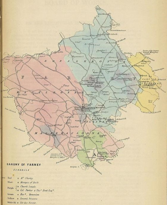
Map from Correspondence relating to measures for relief of distress in Ireland (Board of Works Series)
Some account of the territory or dominion of Farney by Evelyn Philip Shirley https://bit.ly/3cMtNq7
The History of the County of Monaghan By Evelyn Philip Shirley 1879
http://goo.gl/A8s5Zd
A topographical dictionary of Ireland by Samuel Lewis 1840
https://bit.ly/2X9lPAH
For resource available see the Public Records Office of Northern Ireland https://www.nidirect.gov.uk/proni
The History of Donaghmoyne http://donaghmoyne.com/history/